Jakarta Raya in Indonesia: Understanding the Region, Its Cities, and Places to Discover
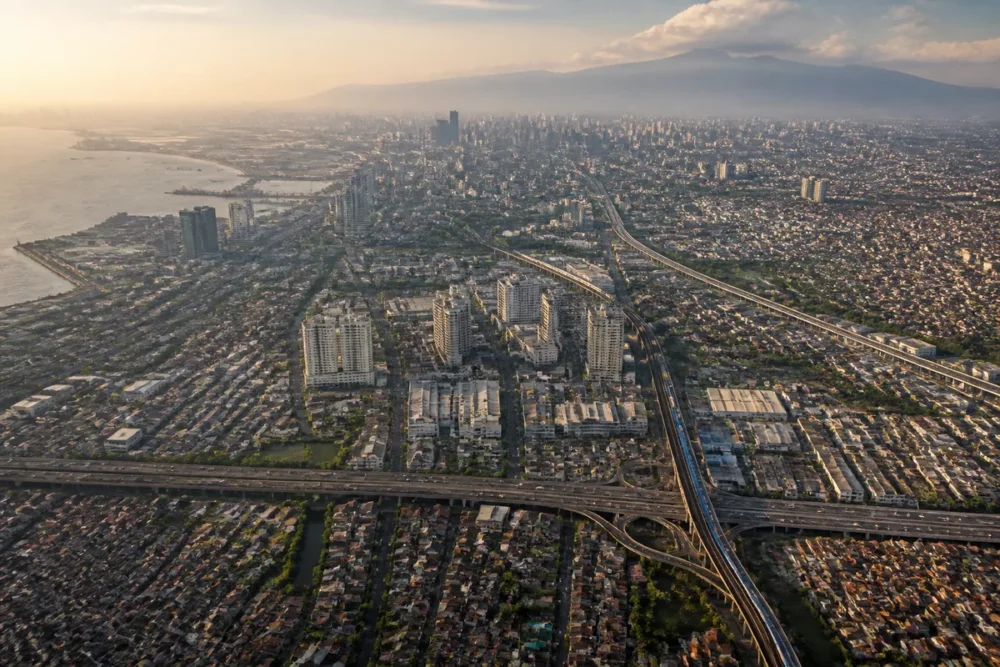
Jakarta Raya in Indonesia generally refers to the large metropolitan area organized around Jakarta, on the northwest coast of the island of Java. The term therefore does not correspond to a single city: it can encompass the special province of Jakarta and the neighboring urban areas of Bogor, Depok, Tangerang, and Bekasi.
The distinction between Jakarta, Greater Jakarta, and Jabodetabek is essential to understand population figures, distances, and travel times. This presentation situates the metropolis, explains its administrative organization, describes its transportation, and offers an exploration of neighborhoods, museums, and neighboring cities.
Table des matières
In brief
- 🗺️ Greater Jakarta is a metropolitan area, while Jakarta is a special-status capital province.
- 🏙️ The term Jabodetabek groups Jakarta, Bogor, Depok, Tangerang, and Bekasi, with statistical boundaries that may vary.
- 🚆 Travel combines TransJakarta, MRT, commuter trains, LRT, and road services depending on the neighborhood and time.
- 🌧️ Heat, humidity, heavy rains, and traffic can significantly alter a visit schedule.
Greater Jakarta: exactly which region are we talking about?
Greater Jakarta is a large metropolitan area that extends around Jakarta and connects the capital province to several urban territories of West Java and Banten. The term is mainly geographical and colloquial: it does not designate a single municipality with a metropolitan administration uniformly covering the entire territory.
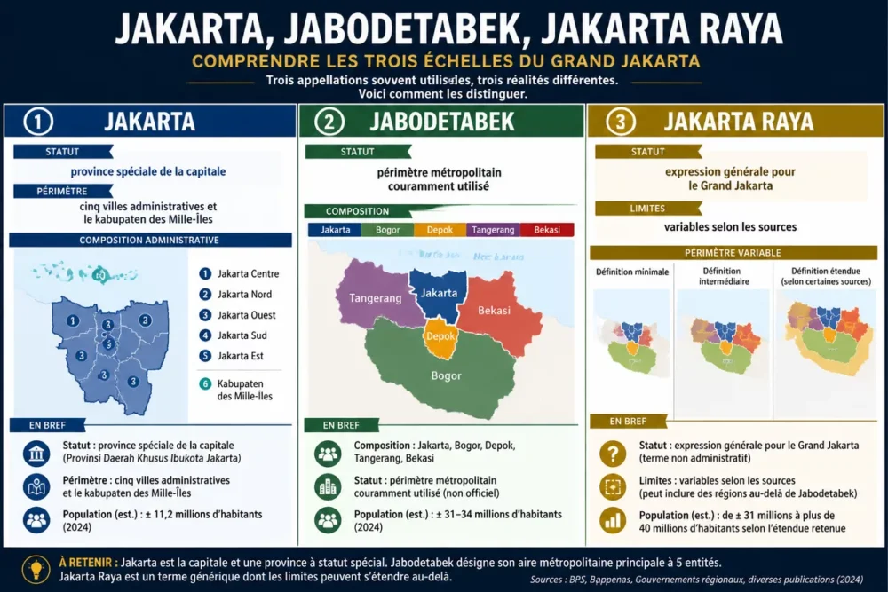
The perimeter most commonly associated with the urban area is that of Jabodetabek, a word formed from Jakarta, Bogor, Depok, Tangerang, and Bekasi. Statistical agencies, maps, and planning documents may, however, use slightly different boundaries. A population figure only makes sense with its year and perimeter.
Jakarta, special province and urban area: three realities to distinguish
Jakarta is a province with special status, officially called Daerah Khusus Jakarta (DKJ) according to Indonesian law no. 2 of 2024. Its territory includes five administrative cities — Central Jakarta, North Jakarta, West Jakarta, South Jakarta, and East Jakarta — as well as the administrative regency of the Thousand Islands.
The five administrative cities do not function as five independent cities comparable to Bogor or Bekasi. They belong to the provincial territory of Jakarta and serve to organize local management. Outside this province begin other communities, notably the city of Depok, the cities of Tangerang and South Tangerang, the regency of Tangerang, the city of Bekasi, and the city of Bogor.
“Jakarta refers to a capital province; Jakarta Raya generally refers to the much larger metropolitan area surrounding it.”
This difference explains why two maps can show different boundaries without necessarily being contradictory. An administrative map will show the province of Jakarta, while a mobility or urbanization map will often represent Jabodetabek.
Where is Jakarta Raya located on the island of Java?
Jakarta Raya is located on the northwest coast of Java, the most populous island of Indonesia. Jakarta borders Jakarta Bay, open to the Java Sea, while the terrain gradually rises to the south, towards Bogor and the mountainous areas of West Java.
This position creates a metropolis organized along a north-south axis and several east-west corridors. The political and economic center is in Jakarta, while the outskirts host vast residential neighborhoods, industrial zones, university hubs, and logistical infrastructures.
| Territory | Position relative to Jakarta | Metropolitan function | Useful landmark |
|---|---|---|---|
| Jakarta | Heart of the capital province | Institutions, headquarters, museums, and major transport hubs | Jakarta Bay to the north, business districts in the center and south |
| Bogor | South of the urban area | Residential, university, and administrative city | Botanical garden and proximity to the hills |
| Depok | South of Jakarta | Metropolitan housing and higher education | Rail corridors to Jakarta and Bogor |
| Tangerang | West of Jakarta | Residential, industrial, and logistical | Access to Soekarno-Hatta airport depending on the sector |
| Bekasi | East of Jakarta | Residential, industrial, and commercial | Strong dependence on road and rail axes |
The territories that make up the metropolitan area
Central Jakarta notably concentrates national institutions, major hotels, museums, and administrative spaces. South Jakarta hosts several business districts, including the Sudirman and Kuningan sectors, while North Jakarta is more linked to the coastline, the port, and the old city neighborhoods.
West Jakarta includes residential, commercial, and historic sectors such as Glodok. East Jakarta extends towards Bekasi and includes many residential and activity areas. The five administrative divisions are therefore complementary, with different urban profiles.
Bogor and Depok play a residential and university role to the south. Tangerang and South Tangerang combine planned neighborhoods, shopping centers, tertiary hubs, and areas close to the airport. Bekasi, to the east, combines strong residential urbanization with significant industrial zones.
Population, density, and economic role of Jakarta Raya
The population of Jakarta must be presented with caution, as the province, the built-up urban area, and the metropolitan area do not cover the same territory. According to the 2020 Indonesian census published by Statistics Indonesia, the national statistical agency BPS, the province of Jakarta had 10,562,088 inhabitants at the 2020 census.
The figure for Jabodetabek is not automatically derived from this value. Counting methods may include or exclude certain regencies, peri-urban zones, or territories functionally linked to the metropolis. Population data for Jakarta Raya must therefore explicitly mention the source, the vintage, and the definition used.
| Data | Value or status | Vintage | Source and precaution |
|---|---|---|---|
| Population of the Jakarta province | 10,562,088 inhabitants | 2020 Census | Statistics Indonesia, BPS; not to be confused with Jabodetabek |
| Organization of Jakarta | Five administrative cities and one kabupaten of the Thousand Islands | Indonesian Law No. 2 of 2024 | Province of Daerah Khusus Jakarta (DKJ) |
“The province of Jakarta and the Jabodetabek metropolitan area must never be used as statistical synonyms.”
The metropolis brings together political, financial, commercial, cultural, and university functions that far exceed the borders of the province. Headquarters, administrations, universities, ports, shopping centers, and airport infrastructures form a network spread between the center and the outskirts.
“In Jakarta Raya, administrative distance is often less useful than the transport corridor and travel time.”
A metropolis with marked urban contrasts
Jakarta Raya juxtaposes business districts with towers, planned housing estates, urban kampungs, and developing suburbs. The disparities concern housing prices, access to public transport, the quality of public spaces, water supply, and proximity to services.
Urban sprawl increases the distance between places of residence and employment. Commuting trips to Jakarta can therefore heavily impact road and rail corridors. Data on the resident population does not directly measure the number of commuters present in the city during the day.
How to get around Jakarta and its metropolitan area?
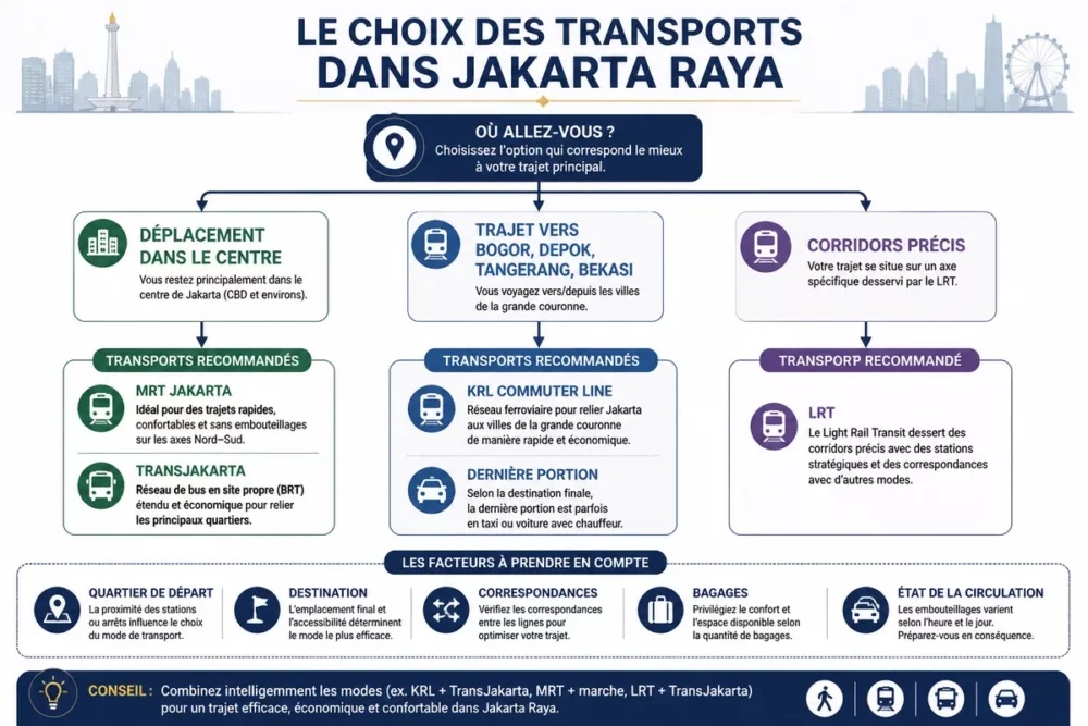
Transport in Jakarta relies on a set of complementary networks: TransJakarta buses, KRL Commuter Line suburban trains, MRT Jakarta, LRT, taxis, and chauffeur-driven car services. The choice depends on the departure neighborhood, destination, connections, luggage, and traffic conditions.
For a trip within the center, the MRT and TransJakarta can be convenient when stations are located near the places visited. To reach Bogor, Depok, Tangerang, or Bekasi, the suburban train is often more relevant than a long road trip, but the last leg sometimes requires a taxi or chauffeur-driven service.
- TransJakarta: bus network useful for many routes in the Jakarta province.
- KRL Commuter Line: trains connecting Jakarta to several peripheral cities, notably Bogor, Depok, Tangerang, and Bekasi.
- MRT Jakarta: metro suitable for certain north-south trips within Jakarta.
- LRT: aerial or elevated network covering specific corridors, with metropolitan extensions depending on the lines in service.
- Taxis and chauffeur-driven cars: flexible solutions, but sensitive to traffic jams and pick-up points.
Getting to Jakarta from Soekarno-Hatta International Airport
Soekarno-Hatta International Airport is located in Tangerang, west of Jakarta, and not in the capital province. The Airport Rail Link train, official taxis, and reserved chauffeur-driven vehicles allow access to different sectors of the metropolitan area.
The real travel time varies depending on the final destination, time, construction works, and traffic. The train can be interesting to reach a point connected to the rail network, while a direct vehicle simplifies luggage transport to a hotel located in a less well-served neighborhood.
- Check the terminal, the exact destination, and the neighborhood of your accommodation.
- Compare the train, the official taxi, and vehicle reservation according to your luggage and arrival time.
- Use only the pickup points indicated by the airport or the booked operator.
- Add a margin for traffic before a domestic flight, an appointment, or a connection.
Halim Perdanakusuma Airport, located east of Jakarta, serves certain domestic flights and may be closer to several neighborhoods of the capital. The departure terminal must be confirmed on the ticket or with the airline, as the two airports are not interchangeable.
What to see in Jakarta and neighboring cities?
Visiting Jakarta becomes more coherent when places are grouped by neighborhood rather than visited according to a scattered list. Kota Tua and Glodok can form a historical and cultural day, while the center around Monas, museums, and institutions offers another perspective on the Indonesian capital.
Kota Tua preserves buildings associated with the city’s ancient history and the Batavia period. The Jakarta History Museum, located in the neighborhood, complements the discovery. The National Museum, the Monas national monument, and the dining areas then allow one to approach political history, cultural collections, and contemporary urban life.
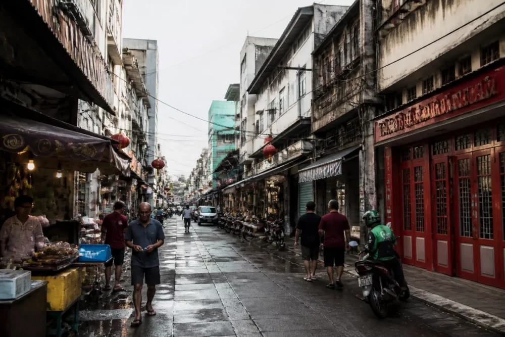
Glodok offers another angle with its shops, dining places, and Indonesian Chinese heritage. Markets, shopping centers, and dining neighborhoods allow discovering a metropolis whose culture is not limited to official monuments.
The coastline and the Thousand Islands can complement a stay when weather conditions, boat schedules, and access rules permit. Bogor constitutes a recognizable excursion from the metropolitan area, notably for its botanical garden and its wetter environment south of Jakarta.
Stay ideas according to available time
Two days allow focusing the discovery on coherent zones: a first route around Kota Tua and Glodok, then a day dedicated to the center, Monas, a museum, and a contemporary neighborhood. Traffic may require reducing the number of places rather than multiplying trips.
With three days or more, you can add Bogor, complementary museums, a market, or a less central neighborhood. The choice of program depends on the accommodation location, opening hours, heat, and weather conditions.
- Two days: Kota Tua, Glodok, museum, Monas, and culinary discovery.
- Three days: add Bogor or a less central cultural area.
- Longer stay: spread visits between Central Jakarta, South Jakarta, the coastline, and a peripheral city.
What climate characterizes Greater Jakarta and how to prepare your visit?
Greater Jakarta experiences a hot and humid equatorial climate, with high temperatures throughout the year. Rain is generally more frequent during the wet season, but the seasons do not always follow fixed boundaries and an intense shower can occur outside the expected period.
The driest months are often preferred for visits, without guarantee of clear skies or smooth traffic. Information from the Indonesian Agency for Meteorology, Climatology and Geophysics, BMKG, should be consulted before trips sensitive to rain.
Breathable clothing, protection against showers, water, and regular breaks make the days more bearable. Heavy rains can cause local disruptions, notably in areas exposed to flooding or on saturated road axes.
Where to stay according to your program?
Central Jakarta suits travelers who prioritize institutions, museums, Monas, and major historical landmarks. Menteng and Thamrin facilitate access to several central sites, while Sudirman and Kuningan are suitable for business districts and certain transport networks.
The western or southern sectors can be interesting depending on the airport used, budget, and planned activities. The distance shown on a map is not enough to choose a hotel: travel time, connections, and travel time matter more.
What are the current challenges of Greater Jakarta?
Jakarta Raya must simultaneously manage flooding, air pollution, traffic congestion, urban sprawl, and land subsidence in certain areas. These phenomena do not concern exactly the same spaces: the coastal risk is distinct from the transportation difficulties affecting many metropolitan corridors.
Water management relies on several levers, including drainage networks, waterways, reservoirs, coastal protection, and the development of urbanized areas. Land subsidence depends notably on geological characteristics and the use of groundwater; its evolution must be analyzed with local and dated data.
Investments in MRT, LRT, the suburban train network, and bus corridors aim to reduce dependence on cars. These infrastructures improve certain corridors, but they do not eliminate transfer and last-mile problems in such an extensive urban area.
The gradual relocation of some capital functions to Nusantara changes the Indonesian institutional landscape, but it does not automatically mean the disappearance of Jakarta’s metropolitan role. The effective distribution of functions and the applicable status must be established from an official dated source.
Why does Jakarta remain the heart of the Indonesian economy?
Jakarta remains the country’s main economic hub thanks to the concentration of headquarters, financial services, administrations, universities, media, and transport infrastructure. The political status of the capital and the economic weight of a metropolis are two different notions, which can evolve at different paces.
An institutional change does not instantly relocate jobs, housing, supplier networks, and transport flows. Even if some national functions are transferred, Jakarta Raya retains an economic and urban fabric built over several decades.
Key Takeaways
- 🗺️ Jakarta is a special province; Jakarta Raya generally refers to its expanded metropolitan area.
- 🏙️ Jabodetabek associates Jakarta with Bogor, Depok, Tangerang, and Bekasi, but the exact perimeter must be verified.
- 📊 Jakarta’s population must be dated and attributed to a source like BPS before any comparison.
- 🚆 Public transport is useful on certain corridors, while road trips remain very variable.
- 🌦️ A successful stay depends as much on the geographic grouping of visits as on the weather and traffic.
Frequently Asked Questions about Jakarta Raya
Is Jakarta Raya a city or an urban area?
Jakarta Raya generally refers to a metropolitan area around Jakarta, not a single municipality. The term can cover different perimeters depending on maps, statistics, and planning documents.
What is the difference between Jakarta, the province of Jakarta, and Jabodetabek?
Jakarta is the common name for the special province of Daerah Khusus Jakarta, which includes five administrative cities and the Thousand Islands territory. Jabodetabek refers to the expanded urban area including Bogor, Depok, Tangerang, and Bekasi.
Which cities are part of the Jakarta urban area?
The main cities associated with Jabodetabek are Jakarta, Bogor, Depok, Tangerang, and Bekasi. Some sources add or exclude peripheral territories depending on the statistical perimeter retained.
What is the population of Jakarta Raya?
There is no single figure valid for all uses, as Jakarta Raya and Jabodetabek do not always have the same statistical perimeter. The 2020 BPS census gives 10,562,088 inhabitants for the province of Jakarta; a metropolitan figure must be cited with its own year, institutional perimeter, and source.
How to get around between Jakarta and neighboring cities?
The KRL Commuter Line trains connect several areas of Jakarta to Bogor, Depok, Tangerang, and Bekasi. The MRT, TransJakarta, LRT, taxis, and chauffeur services complete the network, with travel times highly dependent on the time and destination.
How many days are needed to visit Jakarta?
Two days are suitable for a first approach focused on Kota Tua, Glodok, Monas, and a few museums. Three days or more allow adding Bogor, less central neighborhoods, or an excursion, provided that traffic is taken into account in the schedule.
What is the best time to travel to Jakarta?
Generally drier periods are often more convenient for visits, but Jakarta remains hot and humid all year round. Check the BMKG forecasts, local alerts, and transport conditions before setting excursions.